Sunday, October 11, 2009

Sense of Place: Houston Lake


The early morning photo above is the par-four 18th hole at Houston Lake Country Club. It is considered one of Georgia's finest holes of golf. The first shot, the drive, has to cross a part of the lake. The tee is visible at the upper left. The second shot must cross water again, unless you lay it up, lying somewhere at the right in the photo. The green is in the foreground.

Houston Lake is generously endowed with traits that make up a sense of place. It's remarkable in that the naturally occuring factors seem to weigh about equally with the supporting, intentional ones.

Spanish moss, mature oaks and pines of this traditionally forested area line the fairways and ring the lake. Numerous bird species are always present, and signs warning of alligators greet anyone crossing the club's cart bridges. Squirrels are everywhere, and an occasional rabbit peers out from the edge of a bramble.


Front entrance to club dining room. Part of the experience of place here is knowing that fine dining is available. Along with excellent day-to-day menus, the Seafood Buffet, a monthly event, is a highlight.


Path to the first tee.

Apart from the clubhouse area with its terrace and views of the lake, playing the course offers its own complementary sense of place. There is significant variation in the terrain, with the land rising from lake level and falling toward creeks that run into the lake. This steady change in height adds a quiet drama to movement along the fairways, with sometimes long views alternating with a sense of forested enclosure. Frequent encounters with wildlife punctuate your way through the course as well.


A pair of Canadian geese on 18.


An accomplished group of golfers at the terrace's fire pit after a round. Current senior champion Tommy Toombs, facing the camera, is in the red sweater. He shot his age at 65.


Clubhouse porch over the lake.


Sunset over the 10th hole, from the porch.

All preceding photos this post by club owner Chris Murman.

Sense of place can exist on any physical scale. It can be seen as a room, a house and yard, a country club like this one, a state, region or country; the planet or the universe. The particular scale most commonly in mind when the term "sense of place" is employed is that which is perceptible to the senses at one's immediate physical location.

At Houston Lake, sense of place is experienced in sequences. If one only goes for dinner, the passage through the gateway from the road, into the parking area, and through the front door to the dining room and the view onto the lake makes up the sequence. For golf, the sequence from the parking area is to the right of the building, into the pro shop, then down the path to the first tee, through the course. The round is usually followed by a drink and a visit with playing partners and whoever is encountered inside the grille or on the terrace.

To me, the sine qua non of experiencing this place is sitting on the terrace during fine weather, late in the day as the sun sets over the lake. There is a palpable sense of enclosure and shelter with large trees about you and and the clubhouse's porch and interior spaces of the building at your back. A small shift of the breeze brings cooking smells from the kitchen. A peaceful and spectacular vista of water, sky and forest hangs before you. The Spanish moss, light wind off the lake and the coming and going of friends from the 18th and the clubhouse caps a memorable and complete experience of a unique and deeply comfortable place.

Pulitzer Prize-winning author and architect Robert Campbell, FAIA, wrote an interesting article expressing his take on the subject of golf courses.

The following photos are my own, taken while playing the course. For some, the wildlife is a pleasant part of the background. For others it's a prominent and welcome part of experiencing the course.


Adding meaning to the term "water hazard," and expanding its area. He knows that any ball hit within 30 yards of his front teeth belongs to him.


A goosling settles in.


Squirrel getting ready for winter.


Great Blue Heron taking flight.

Monday, October 5, 2009

Sense of Place: 1, Definitions

Some definition of the term "sense of place" is needed before getting into its discussion. At its most basic, it simply means the specific nature of our immediate surroundings and our awareness of them. But, because a place can have so many elements in its composition, and its perception varies among us anyway, defining "sense of place" can become a lengthy effort. It actually amounts to an academic discipline all of its own. Whatever appears in this post, more will likely follow in future posts on the subject. Here's what Wiki has to say about it.
.

In architecture, it would seem that the more factors that contribute to building a sense of place the designer understands, the better. Christian Norberg-Shulz's book, Genius Loci, is a definitive examination of phenomenology of architecture. "The distinctive atmosphere or pervading spirit of a place."
.
If we had a heads-up display for assessing sense of place, it might have a list of factors to one side with little red lights beside those present in the place. Part of the list might include physical comfort, memorability, uniqueness, security, spatial definition, a view beyond, people, beauty, available food and drink, well-designed or naturally-formed places to sit, weather, lighting, connection to nature, symbols representing one's values, familiar or newly intriguing fixtures. The list could go on to include spatial scale of intimacy or grandeur, sounds, smells, tactile objects and more. The point is, many factors can come into play.
.
To me, sense of place implies a relatively intense experience. This experience is formed by inherent attributes of the place itself, and by the current perceptual traits of the person who's experiencing it. The designer obviously can't satisfy the needs of every state of mind a place's users bring to it. Awareness and the best available accommodation of perceptual variations is all one can offer.
.
The more comfortable or meaningful a person finds a place, the better. Comfort can be nurtured by many things, but the most relevant are those which foster memories. A sense of feeling welcome, relaxed, often but not necessarily of specific spatial enclosure, of association with friends, family or allies are desirable. Familiarity with the place can contribute, but strong sense of place can occur without it. Some of the strongest experiences of place in one's lifetime can be diverse. A cozy, secure room in a house with a roaring fireplace might be one, while a grand landscape with a sweeping view of an immense mountain range may be another.
.
A sense of place can be designed or supported to a significant degree, or it can evolve without conscious intervention of any particular kind. Architectural design is, it's hoped, heavily influenced by the idea of a sense of place. Come to think of it, running a successful restaurant needs the same kind of sensibility.
.
If there is one attibute that is most closely associated with sense of place, it would probably be that of the place being memorable.
.
A Canadian geographer and professor at the University of Toronto, Ted Relph, gives a great deal of insight into sense of place. His book, Place and Placelessness, brings academic rigor to the subject which is often only fuzzily grasped by many who most need to understand it, architects. Dr. David Seamon, a professor at Kansas State University, teaches and researches this subject in a helpful and focused way. His article on Relph's work is in itself an excellent explanation of essential elements that make up what is known as sense of place.
.
I've mentioned him in earlier posts, and
Christopher Alexander offers some of the best insight into sense of place, even when he's specifically talking about other things. His books, The Timeless Way of Building and A Pattern Language are great explorations into place and the things which resonate with us in the way we experience it.
.
Further links:
.
Ted Relph. Yosemite as a Mythical Place.
Barbara Allen and Thomas J. Schlereth, Sense of Place: American Regional Cultures.
Maria Lorena Lehman, Sensing Architecture.
.

.
Early morning, Houston Lake Country Club, subject of the next post. Click image to zoom.

Saturday, September 26, 2009

Urban Design: Macon, Civic Square


.
Civic Square, Macon, Georgia proposed development. Click image to zoom.
.
A Texas native, I joined Dennis & Dennis, Inc., an old Macon firm, in 1987. One of the things that drew me to the city was the promise of its historic downtown.
.
A few years after moving here I worked with another Macon architect, Shannon Fickling, to develop initial plans for a park located on land between City Hall and the Macon Auditorium. The land was roughly triangular in plan, because downtown's one diagonal street, Cotton Avenue, cut through the site. Cotton Avenue is believed to fall on what was the old Federal Road from Washington to New Orleans, commissioned by President Jefferson in 1806.
.
The land in question had housed several buildings, visible in this photograph. Click on photo for full view.
.
.
City Hall is visible at lower right. The site initially ran from the building with the Uneeda Biscuit sign and buildings immediately behind it. The two-story house to the left of the Biscuit sign is the present site of the Shrine Temple building.
.
The project languished due to funding. I started my own practice after several years with the Dennis & Dennis firm. Funding was finally secured for basic parts of the project. I was selected by the City of Macon for overall, long-term planning and the immediate, specific design of the paving, landscape and lighting.
.
(The Georgia Department of Transportation decided to close off Cotton Avenue in this block because the relatively small triangular layout posed the problem of traffic backing up into adjacent streets. This left a rectangular site to work with, and improved pedestrian safety, at the cost of breaking up the function of the historic path of Cotton Avenue.)
.
The photo below, viewed from the opposite direction of the preceding early 20th-century picture, shows the site prior to early work on this project. The last buildings that had always separated the 1841 City Hall from the 1925 Macon Auditorium had been removed.
.
.
City Hall at center. Al Siha Shrine Temple right. Volunteers' Armory at left. Macon Auditorium off the photo, lower right area.
.
This is a long-term plan. The essential fact of the park, with walkways, lighting and plant material was completed in the Mid-1990's. Further property acquisition remains for completing the landscaped square.
.
The proposed eventual solution features a realignment of 1st Street, which runs back from the left foreground in the above photo; elimination of one block of the diagonal Cotton Avenue; landscaping of the main space running from City Hall to Macon Auditorium.
.
.
The overall plan above shows existing buildings City Hall at top, Macon Auditorium at bottom. Macon Volunteers' Armory is at left, and Al Sihah Shrine Temple at right. A diagonal walkway, made with underlying original brick street pavers, is shown, centered on the Cotton Avenue corridor. If the street was to be interrupted, the view of the historic path would be preserved. An optional fountain was proposed, pending acquision of the final sections of property between City Hall and the Macon Auditorium.
.
.
Along each side of the main lawn are two rows of trees, with 15-foot by 20-foot seating areas defined by the trees and rows of azaleas. Each of the "rooms," based on the design of the Charleston Waterfront Park, enable commemoration of a number of individual people or events, while maintaining an overall civic square. The overall square was named Rosa Parks Square in 2003.

Thursday, September 24, 2009

Urban Design: Paris' Axe Historique


Axe Historique. Click image for full view.

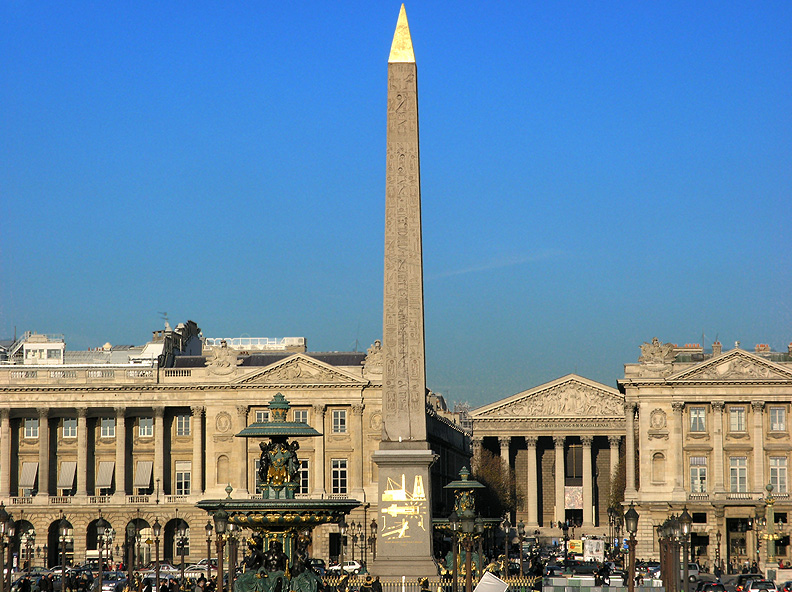
Paris' Axe Historique is a shaft of space running east-west along the Champs Elysees. Few places are so steeped in the history of a country as this. The Louvre began as a medieval fortress on Right Bank of the River Seine, built by Philip II in the 12th century. West of the Louvre, the Place de la Concorde, originally named Place de Louis XV in 1755, was the site of over 1,000 public executions in the 18th century. These were initially execution of convicted criminals, and concluded with execution of royalty, previously spectators, during the French Revolution. Today this large square is centered on the Obelisque de Luxor, a 3,500-year-old Egyptian relic given to France in 1833.


Obelisque, at Place de la Concorde. This view is perpendicular to Axis, facing north.

The axis began as a vista to the west from the Louvre. Construction of the Champs-Elysees was, in effect, commissioned by Marie de Medici in 1616. Initially defined by rows of trees running parallel to its length, this avenue ran west through open fields from the Tuileries Palace toward the eventual location (1810-1833) of the Arc de Triomphe.


Champs-Elysees. 1890.

The Louvre, the older palace, is adjacent to the Tuileries site, and survived the fire set by the Paris Commune that consumed Tuileries in 1871. After destruction of the Tuileries, its site was landscaped, becoming the Tuileries Garden. The Arc de Triomphe du Carrousel, a smaller version of Arc de Triomphe, is located on the axis between the former Tuileries Palace site and the Louvre.


Camille Pissaro. Morning, Winter Sunshine, Frost, the Pont-Neuf,
the Seine, the Louvre, Soliel D'hiver Gella Blanc. 1901.

So, the arrangement of the Axe Historique was cast, with the Louvre at the east end, the Arc de Triomphe at the west.


Facing east from the Arc de Triomphe.

The Champs-Elysees quickly began to develop with shops, homes and offices behind its defining rows of trees. After the French Revolution in 1789 and the end of monarchy, the Louvre was officially designated a museum in 1793. It had functioned as a museum for a hundred years, since Philip moved the household to Versailles. As the east end of the Axis, the historic, prominent site has been nurtured and carefully expanded over the years, now containing over 650,000 square feet.


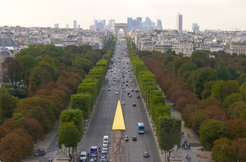
Facing west. Oblisque in foreground, Arc de Triomphe beyond. La Defense on the horizon.

This monumental construct of national pride is the definition of pomp. The Axe Historique might be too vast and ostentatious to be enjoyable, were it not for the context of its intentions, its intricate, fascinating history and the charm of all its adjacent streets, the river and interconnecting places. As it is, this primary space of what is widely considered the world's most beautiful capital seems fitting and properly scaled for its nature. It's truly magnificent.

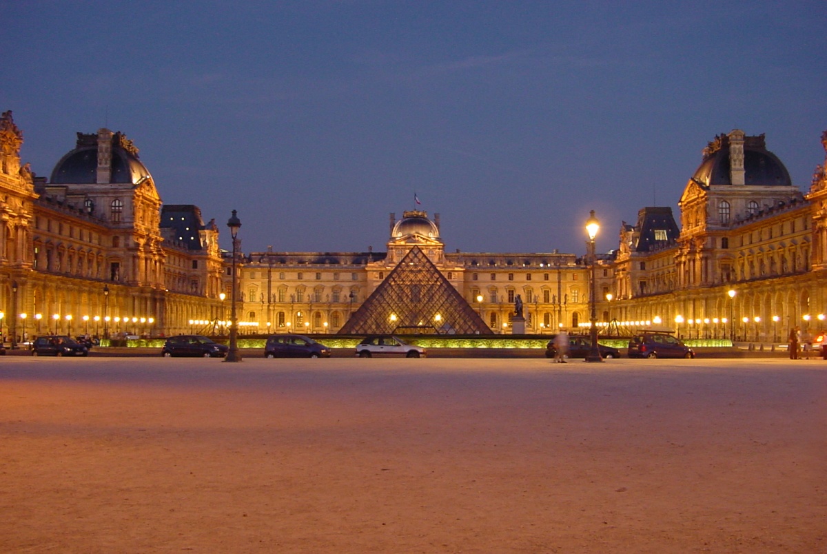
Below, Current photo of the Louvre at dusk. I.M.Pei's pyramid. Wiki.
As all images this post, please click on image for full view.


Link: Thomas Mayer's photos of the Louvre Pyramid.

Saturday, September 19, 2009

Urban Design: Charleston Waterfront Park


Waterfront Park's pier at sunrise.


Facing the city from the pier, aligned with Queen St beyond.

Charleston is probably the US's most prominent historic preservation city. Other cities had as much or more history, but they haven't matched Charleston's preservation efforts. The Preservation Society of Charleston preceded the National Trust for Historic Preservation by almost 30 years, and is one of the most successful preservation operations in the world. The National Park Service has a concise page on the means by which the city's preservation has been accomplished.


Promenade, facing north. The pier and Ravenel Bridge beyond.

Approaching the city by car from the west, you cross the bridge and see the skyline. Thanks to the city's building height restrictions, nothing exceeds probably four stories except seven or eight tall church steeples. All of them were built prior to enactment of the height restrictions.

Charleston holds a number of places that are rewarding to visit and to study. There are few places where urban design has been so interwoven with historic preservation. Even the most casual visit is rich in images, good restaurants and recreational opportunities. It's a world-class stop on any tourist's list. I recall one visit when standing on the outer walkway of the Waterfront Park's pier, a film crew was shooting scenes in a movie, and the Queen Mary II was part of the backdrop.
.
The Waterfront Park owes its existence to Mayor Joe Riley. Shortly after election in 1975, he began making plans for a park in that location. It took 15 years (Charleston doesn't have term limits for the office of Mayor,) but the park opened in 1990, even after damage during construction caused by Hurricane Hugo.


Shaded walk. A series of shaded "rooms" with chairs or
benches are to the left. One is shown below.


Designed by Sasaki Associates' Stuart Dawson, this park is a significant amenity in a city already rich in amenities. (Note, the link to the Sasaki site has an excellent aerial view of the entire half-mile-long park.) This design benefits from mature and refined judgment, in addition to plenty of talent. Too many efforts to design places of this nature contain overwrought, busy spectacle of too many "flowers" and not enough "grass." That is, special features are too numerous, so that they become undifferentiated and the design loses resonance and an appropriate sense of the drama that truly significant features deserve. This one gets it right. The ratio of "flowers" to "grass" feels perfect.
.
Special features here are the view of the harbor, Ravenel Bridge, Fort Sumter, the fountain, the pier, the long row of shaded seating areas, the promenade. All this is mentally framed within the adjacent context of the historic city. There is a serenity in the broad expanse of the harbor and the lawns, which act as background, or "grass" for the focal points, the "flowers," of this place.
.
The city is incredibly walkable - it's one of those places that, when you're driving, you immediately want to find a place to park the car so you can get out and walk - and each street in its historic area is a delightful experience. The beautifully appointed park offers a place to sit, take in the view of Charleston Harbor and the sea, watch people and rest before diving back into the often tighly-defined spaces of the streets.


Fountain. Formed as a pineapple, symbol of hospitality.
(Excellent photos of this fountain and the area are in anadelmann's flickr set here. )

Photos in this post are my own unless otherwise noted. You are welcome to use them as long as you give me credit, by noting russellclaxton.blogspot.com.

Wednesday, September 2, 2009

Urban Design: Navy Memorial, DC

Washington, DC has some of the world's most enjoyable urban landscape. Like Chicago's Grant Park, some of the larger landscapes such as parts of the Mall are utterly lacking in human scale. However, the city is thoroughly saturated with more compact parks and streetscape that combine with the grander landscapes in a satisfying way.

The Navy Memorial is a successful urban space. Beautifully landscaped and paved, the site is positioned across Pennsylvania Ave from the National Archives. A steady stream of pedestrians come and go from the Archives Metro station entrance in the trees at the edge of the space.

A group of fountains surround the main paved space, with its map of the world set in two colors of granite. At the edge of the street, two masts flying signal flags are set between the curb and a straight section of fountain with heavy, rising water jets. The edge of the pavement parallel to the curving building facades contains cascading fountains and bas-relief brass depictions of historic Navy events. The surrounding presence of the sight and sound of splashing water provides a lively background to the plaza. There is a palpable sense of place.The landscape materials are beautifully chosen and placed.

The plaza itself is well-defined spatially by the immediately adjacent twelve-story buildings. The spatial relationships between other related buildings, some dramatically axial, are highly articulate. Particularly remarkable is the spatial axis from the National Archives, through the Navy Memorial plaza and to the Smithsonian Art Museum to the north.

I think it's one of Washington's most enjoyable spaces.


Facing west. The Archives Metro entrance just past the low wall at right.
Click on photos for larger image.


Turning to the East from preceding photo.


National Archives across Pennsylvania Ave.


The National Archives, beyond the Navy Memorial plaza.
The Lone Sailor statue is at right.


Masts with signal flags near the curb.

Photos in this post are my own. You are welcome to use them as long as you give me credit, by noting russellclaxton.blogspot.com with the photo.

An excellent separate photo set is here at Flickr, with a shot inside the Metro entrance. Mr T in DC.

Monday, August 31, 2009

Urban Design: Washington, DC and Paris


Camille Pissarro, Boulevard Montmartre au printemps, (1897)

Washington and Paris share remarkably significant traits, along with readily apparent differences. As national capitals, shared traits include numerous monuments, grand rivers and diagonal boulevards, excellent transit systems, signature totems positioned in vast parklands (Eiffel Tower and Washington Monument.) The traffic circles in both cities, made necessary by the diagonal bouleveards' intersections with other streets, create parks and landscaped areas that generally don't exist in rectangular street grids.


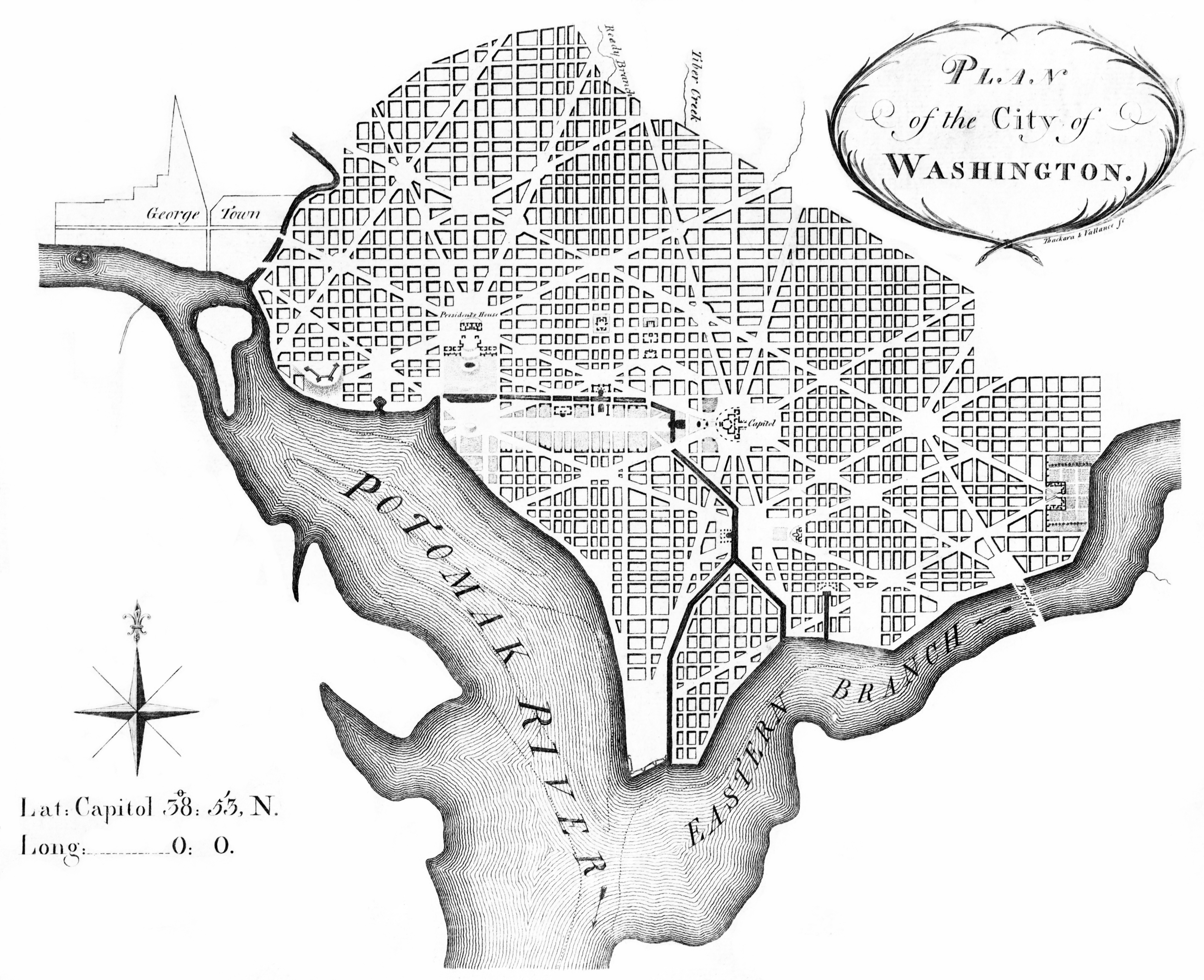
L'Enfant's plan for Washington, DC, as revised by Andrew Ellicot, 1792. Wiki. Click image for full view.


Michael Kooiman. wiki.


My photo.


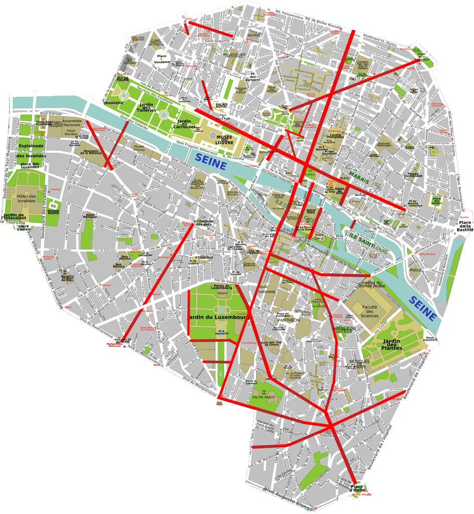
Napoleon Napoleon III and Haussmann's changes to Paris. wiki. Click image for full view.

DC is remarkable in that it was cast as a new city, with a sweeping master plan of streets, parks and primary structures. Yet, the city has a rich variety of architecture and urban spaces owing to the infill that occurred between the Olympian scale of initial placement of the Capitol and the White House, along with the Parisian diagonal grid and its traffic circles.

Paris was a very old city with a medieval character and its grand boulevards were, over time, cut through existing urban fabric by successive emporers, primarily and most recently Napoleon III. Its buildings are commonly made of limestone, uniquely available from vast mines below the surface of the city. Washington was the first national capitol to be laid out according to the design of a specific planner, Pierre L'Enfant. Even the most casual comparison of the two cities' maps shows the organic, complicated geometry of Paris in sharp contrast to the generally rectangular grid of Washington set in juxtapostion to its diagonal boulevards.

Both cities, though, have beautiful rivers, a wealth of parkland, generous public squares and "left-over" spaces created by the intersection of diagonal corridors with the differently-aligned adjacent streets. Their transit systems are both excellent. Paris' opened in 1900, DC's in 1976.

Paris' changes commissioned by Napoleon III were undoubtedly admired by Daniel Burnham, he of the "Make no small plans" quote. I don't believe that any existing city, without destruction by war or other disaster, has ever undergone rapid, planned changes of this magnitude. The emporer chose Georges-Eugene Haussmann to plan and carry out the changes to the city.


My photo. Street-performing band at DuPont Circle, DC. Despite the weight of government, both cities sport famously lively streets. Here's one from Paris.

Additional posts about some of the public spaces that have been created in both these cities will follow from time to time.

Saturday, August 15, 2009

Form Follows Function: 4, Architectural Design


1977. Pompidou Centre. Exposed trusses, ducts, electrical conduit, metal decking.
From *clarity*'s photostream, flickr.

Last of the form / function posts, for now anyway.

Functionally-shaped buildings are remarkably hard to find, other than limited groups which have clear and apparent forces at work to determine their forms:

Tents make up one group, with their push-pull structures and pliant envelopes. Some creative examples.

Yurts are another, or maybe a subgroup of tents.

Some industrial uses make up another group, with facilities like oil refineries, rail service structures and grain elevators.

Mobile dwellings, notably Airstream, are another. Houseboats, ocean liners and today's cruise ships are less confined in their formal characteristics than some of the structures in this list, but are quite recognizable for what they are and the purposes they serve.

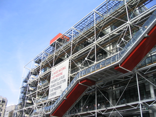
The presence of functional imargery in building types without the overwhelming incentives present in the examples of the preceding list are much less common. This isn't surprising, but it can sometimes be a missed opportunity to mine the aesthetic potential latent within many buildings' program requirements. Renzo Piano and Richard Rogers designed the iconic and widely-appreciated Pompideau Centre in Paris. This museum is generally described as "high tech," but along with its high-tech imagery, it represents a studied effort to thrust many of the building's functional elements and processes into view.


Pompidou Center. wiki


From lewishamdreamer's photostream, flickr
Detail photo of Pompidou Center. Exposed structure, electrical conduit, service access platforms, welded wire mesh railing. This thirty-two-year-old building bluntly delineates functional elements as a deliberate, carefully composed aesthetic.

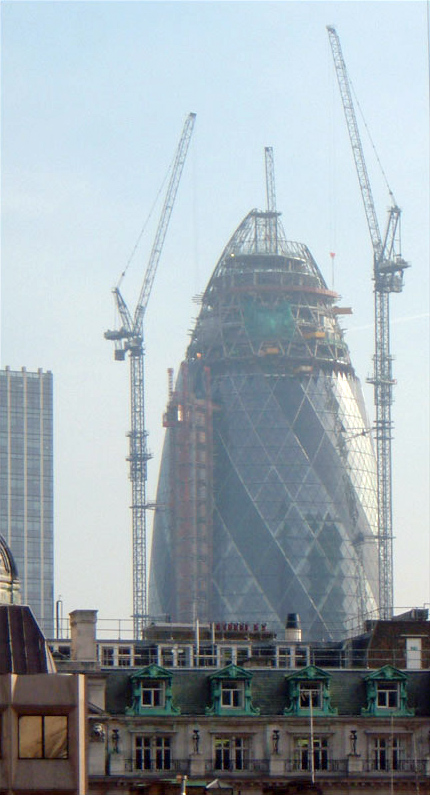
Rogers' one-time business partner, Norman Foster, carried his own inquiries into technical expression of functional imagery into the production of highly accomplished work. His firm's 30 St. Mary Axe office building in London is an exemplary collaboration between the architect, structural engineer Ove Arup and mechanical engineer Hilson Moran. The interwoven design is explained in this wiki article. It's unmistakable on the skyline, and has prompted hilarious nicknames, but is highly sophisticated structurally and mechanically. With due acknowledgment of "Towering Innuendo" and "Chrystal Phallas" nicnames, the more primary formal expression of this building is, I think, its triangulation of structure and aerodynamics, which evade wind loads while driving its natural ventilation system.


30 St. Mary Axe. London.

Through the broad sweep of architectural history, form has ebbed back and forth from unadorned functional construction to highly stylized periods like 16th-century mannerists of Italy or 18th-century Roccoco. The thrust has almost always been toward more sylized imagery. In the examples of mannerism and later roccoco, a stylisitc evolution matured, where increasingly numerous, layered factors influenced architectural expression with only the minimum necessary evidence of functional elements. In fact, function is often hidden, disguised or sacrificed to satisfy formal considerations. (Ironically enough, this occurred commonly enough in the 20th century and even now, trying to give a building a functional and machine-like image when its actual construction was of earlier, more primitive means and materials.)

Among factors likely to introduce opportunities for less arbitrary building imagery are those related to sustainability and the conservation of energy. Provison of fixed or movable shading devices, permeable, "breathing" envelope systems and wind turbines of various configurations can have substantial visible effect on a building's form. Partially underground construction is another potential form-giver. Integration of building envelope with plant material in both traditional and yet-to-be-developed ways offer intriguing departures from past and current design precepts.

Without trying to turn this into a manifesto, I think it quite possible that necessities of sustainability and conservation of resources, already increasingly evident, will over time usher in a technically sophisticated, broad design motif of literal and honest expression of function. Along with this, a new and widely understood aesthetic can evolve. Would or should this become a dominant aesthetic? I hope no realtively narrow aesthetic vision ever becomes "dominant," but I think new forms based on new capacities to intrepret and produce them is positive and an altogether exciting prospect.

Of general interest, an outstanding archive of Thomas Mayer photos.